Expert Seminars
Expert Seminar on History and Archaeology: Virtual History and Archaeology Report
A Better Understanding of the Past
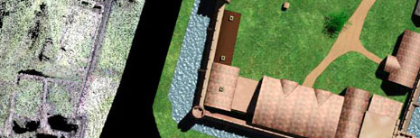
Historians and archaeologists have engaged in informed and advanced debates within their respective communities on the questions of how ICT can enable a better understanding of the past. Until now there has been little opportunity for cross-disciplinary exchange of ideas. This seminar was an important opportunity to address this issue, and a primary goal of the event was to encourage crossdisciplinary collaborations. The expert seminar took place over three days with an ambitious programme that covered a wide-ranging set of disciplines, tools and methods. The programme focused on three subjects: the past and virtual representation of® place and time; the past and virtual representation of texts; the past and representation of objects and events. Each session brought together specialists in the application of ICT to the historical and archaeological domains; recognizing that the two disciplines have much in common, yet are frequently isolated from one another.
AHDS Methods Taxonomy Terms
This item has been catalogued using a discipline and methods taxonomy. Learn more here.
Disciplines
- History
- Archaeology
- Ancient History
Methods
- Communication and collaboration - Graphical collaborative publishing
- Communication and collaboration - Textual resource sharing
- Communication and collaboration - Graphical resource sharing
- Data Analysis - Content analysis
- Data Analysis - Data mining
- Data Analysis - Record linkages
- Data Analysis - Searching/querying
- Data Analysis - Visual analysis/visualisation
- Data Analysis - Predictive spatial modelling
- Data Capture - 2d Scanning/photography
- Data Capture - 3d modelling - vector - volumetric
- Data Capture - Digital aerial photography
- Data Capture - Digital remote sensing
- Data Capture - Geophysical survey
- Data Capture - GPS/total station surveys
- Data Capture - Usage of existing digital data
- Data publishing and dissemination - Cataloguing / indexing
- Data publishing and dissemination - Image optimisation for the web
- Data publishing and dissemination - Searching/querying
- Data publishing and dissemination - Graphical resource sharing
- Data publishing and dissemination - Textual resource sharing
- Data Structuring and enhancement - 3d animation
- Data Structuring and enhancement - 3d modelling - interactive
- Data Structuring and enhancement - 3d modelling - vector
- Data Structuring and enhancement - 3d modelling - vector - point cloud
- Data Structuring and enhancement - 3d modelling - vector - surface
- Data Structuring and enhancement - 3d modelling - vector - triangular network models
- Data Structuring and enhancement - 3d modelling - vector - volumetric
- Data Structuring and enhancement - 3d modelling - vector - wireframe
- Data Structuring and enhancement - Coding/standardisation
- Data Structuring and enhancement - Data modelling - relational
- Data Structuring and enhancement - Geo-referencing/projection
- Data Structuring and enhancement - Graphical rendering
- Data Structuring and enhancement - Image enhancement
- Data Structuring and enhancement - Image restoration and rectification
- Data Structuring and enhancement - Markup/text encoding - descriptive - document structure
- Data Structuring and enhancement - Markup/text encoding - descriptive - nominal
- Data Structuring and enhancement - Record linkages
- Data Structuring and enhancement - Virtual world modelling
- Strategy and project management - Data protection
- Strategy and project management - Documentation